
 |
|
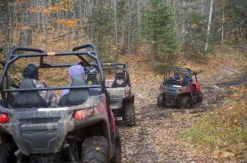
Thrilling ORV rides, outdoor exploring and forest adventures are waiting down one of Michigan’s thousands of miles of state forest roads. Every year, the DNR updates maps of these roads to improve accuracy and protect the environment, and then notifies the public of any changes. New maps go up at Michigan.gov/ForestRoads Friday, April 1, in an interactive web format and as printable PDF maps. Map changes are based on considerations that include changing road conditions, data cleanup and input received from residents around the state. Maps show where state forest roads are open or closed to off-road vehicle use and which roads are only open to conventional vehicles. It’s important to stay on these roads when using motor vehicles to reduce erosion and damage to wildlife habitat. The following mileages will be open to ORVs starting April 1:
|
Trial access at Camp Grayling
New this year is a trial opening to ORV use of nearly 95 miles of forest roads located within the Camp Grayling training area in Crawford County. The roads, located on 16,000 acres of state forest lands leased from the DNR for military training, are north of County Road 612 near the city of Grayling.
The forest roads will be open to the public when not in use for military training. When the area is used for training activities, roads will be gated off for public safety. Notice will be posted on the Camp Grayling Joint Maneuver Training Center Facebook page and shared on local radio stations.
Review ORV rules, regulations, closures and more at Michigan.gov/ORVInfo. Find maps and other information at Michigan.gov/ForestRoads.
Questions? Contact Jason Caron at 906-235-4361.