
The Michigan Department of Natural Resources has announced significant traffic circulation improvements and the upcoming completion of a dedicated two-way cycle track at Belle Isle Park.
Visitors will see the implementation of some of the recommendations from the 2025 Belle Isle Park multimodal mobility plan, designed to ease traffic congestion, enhance accessibility and increase public safety for all park users.
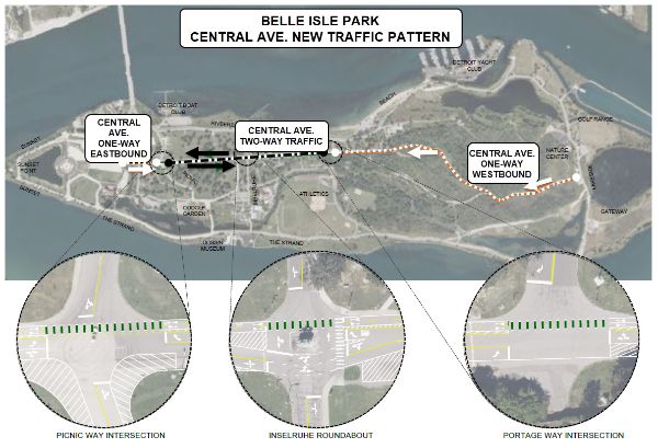
Traffic circulation improvements
To help ease vehicle traffic flow, Central Avenue will transition to two-way vehicular traffic from Picnic Way to Portage Way. The scenic route through the wet mesic flatwoods – a rare, 200-acre forested wetland located in the center of the island – will shift direction, moving from one-way eastbound to one-way westbound traffic.
"Providing additional westbound traffic from the east end of the park will support reducing traffic congestion on Riverbank, particularly at the beach area, where traffic congestion has been identified as a safety concern," said Amanda Treadwell, urban area field planner for the DNR Parks and Recreation Division.
Dedicated two-way cycle track
Additionally, the new, two-way cycle track will provide a continuous, separate bicycle loop that follows the perimeter of the island. Road cyclists will soon be able to circle the entire park without crossing vehicle traffic lanes. To further enhance safety, the MacArthur Bridge entry and exit points will feature high-visibility road markings and clear signage to safely guide cyclists and drivers through crossings.
"This new, two-way cycle lane will help advance our goal of enhanced multimodal mobility and recreation opportunities in the park," said Treadwell. "We're asking high-speed cyclists to use the road's cycle track, which allows walkers and casual riders to safely enjoy the Ralph C. Wilson, Jr. Trail at their own speed."
Timeline
The transition will occur in stages, and all work is weather-dependent:
- Week of May 18: Two-way cycle track markings are scheduled for Casino Way and The Strand in areas previously unmarked.
- May 26-29: Central Avenue will temporarily close for new traffic pattern work.
- May 29 (tentative): Central Avenue will reopen with a new traffic pattern.
- June 1-5: If needed, intermittent lane closures will take place along Central Avenue to complete parking space striping.
Visit Michigan.gov/DNRClosures to find anticipated closure dates and additional information on this enhancement project. Any revised construction timelines will be announced on the closures page.
Later this summer, visitors can expect additional wayfinding improvements, including new directional and facility signage designed to make the park more intuitive to navigate for first-time and frequent visitors alike.
For more information, contact Amanda Treadwell at TreadwellA@Michigan.gov or 313-269-7430.