
|
Director Dan Eichinger at the February meeting of the Michigan Natural Resources Commission and implemented by DNR forestry staff in the weeks since.
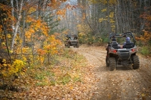
Final maps detailing the 6,339.5 miles of northern Michigan state forest roads open to ORV use – as well as printable maps by county – now are available on the DNR website.
To ensure maps for all state forest roads stay up to date, the DNR will evaluate road data in response to changing road conditions and uses and update maps every year on April 1. All off-roaders are encouraged to regularly check maps to make sure they are in compliance with rules for riding ORVs on state forest roads.
It’s all part of a multiyear process tied to P.A. 288 of 2016, which directed the DNR to comprehensively map and inventory all state forest roads and make determinations on the open/closed status of each road. The DNR completed a similar evaluation and work for state forest roads in southern Michigan and the Upper Peninsula at the end of 2018.
Overall, there currently are nearly 7,600 miles of state forest roads in the northern Lower Peninsula. The most recent mapping and inventory review process yielded a net increase of 31.5 miles of roads open to ORV users, compared to a year ago. A few miles were closed to ORV use due to damage and the need for natural resources protection.
“This was a great effort to increase the accuracy of our state forest road system, be responsive to the variety of recreation uses that occur on state-managed lands, and ensuring the protection of our valuable natural resources,” said Bill O’Neill, DNR natural resources deputy director. “DNR staff will provide regular updates to the state forest road inventory and ensure appropriate use of these roads.”
Public feedback was a critical part of the mapping and inventory process, and the DNR will continue to provide the opportunity for people to share their comments and ideas about proposed road changes for the next round of statewide map updates. People can view all maps at Michigan.gov/ForestRoads and submit feedback via the interactive maps. To have comments considered for potential changes to the 2020 maps, feedback must be submitted by Aug. 31, 2019.
For more on off-road vehicle opportunities statewide and other need-to-know information, visit Michigan.gov/ORVTrails.
Contact: Kerry Wieber, 517-643-1256