
|
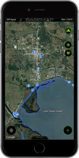
BOTHELL, Wash. (August 1, 2018) – Anglers and boaters will benefit from the latest updates announced by BaseMap, Inc., creators of the BaseMap mobile and web hunting, fishing and outdoor activities mapping app. BaseMap users can now locate public fishing locations and water access points across the United States effective immediately.
The Nationwide Fishing Points of Interest layer uses state-provided data to identify fishing piers, fish cleaning stations, man-made fish habitat, license vendor locations and bait shops throughout the U.S. Eliminate long, wasted drives and precious fishing time by using BaseMap to easily find the boat ramp or water access point.
These two new additions are available to all BaseMap users by updating the app. Not yet a member of the BaseMap family? BaseMap is available on iOS and Android platforms, and online at app.basemap.com. Find more information about how to use BaseMap, tutorial videos and information on specific individual outdoor activities atbasemap.com.
For iOS download from the App Store here.
For Android download from Google Play here.
BaseMap offers a comprehensive mapping solution for all outdoorsmen and women providing more than 700 layers of detailed mapping information from private and public land boundaries, when and where to hunt, fishing access, hiking trails, 4x4 routes, wildfire information and much more to help plan the next hunt, fishing trip or backcountry adventure.
Nationwide parcel ownership information is available with the BaseMap Pro subscription costing only $29.99 annually or $4.99 a month.
Follow BaseMap on Facebook, Instagram and YouTube.
About BaseMap
BaseMap originally came onto the scene in April of 2016 and offered a mapping and hunt planning application that was user friendly and ahead of its time. With years of dedication and attention to detail, the re-launch of this exciting brand is giving outdoorsmen and women exactly what they need. This is a way for everyone to have an affordable tool that will be essential to every step of every outdoor adventure. The updated product features nationwide coverage with hundreds of layers including nationwide private parcel names and boundaries, nationwide lakes and rivers, habitat range information, hiking trails and much more. BaseMap’s vision is to empower everyone to Own The Outdoors.
Contact: Jordan Egli
Blue Heron Communications
(405) 364-3433